
2018 Adventures
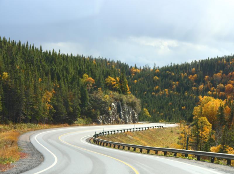
The weather is a bit cool today with the occasional misting. Rain gear on, we loaded up Roxy and headed out to explore Gros Morne National Park a bit more.
Gros Morne National Park the moose population density is one of the highest in North America. The park is also home to woodland caribou and black bears. Unfortunately we did not see any of the moose
brenda stanger
104 chapters
16 Apr 2020
Newfoundland - Rocky Harbour
October 15, 2018
|
Day 2 - Rocky Harbour
The weather is a bit cool today with the occasional misting. Rain gear on, we loaded up Roxy and headed out to explore Gros Morne National Park a bit more.
Gros Morne National Park the moose population density is one of the highest in North America. The park is also home to woodland caribou and black bears. Unfortunately we did not see any of the moose
population while we were here. It might be hunting season that is driving the majestic creatures further into the wilderness.
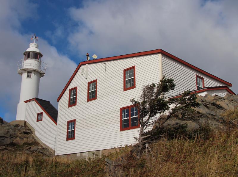
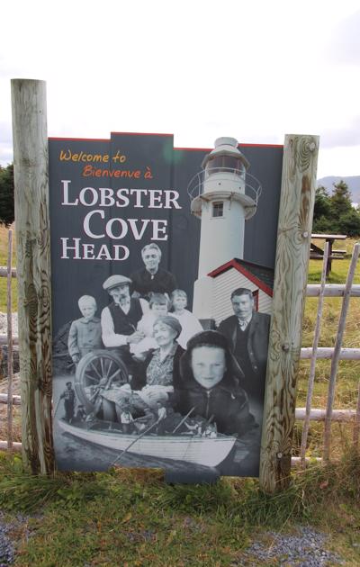
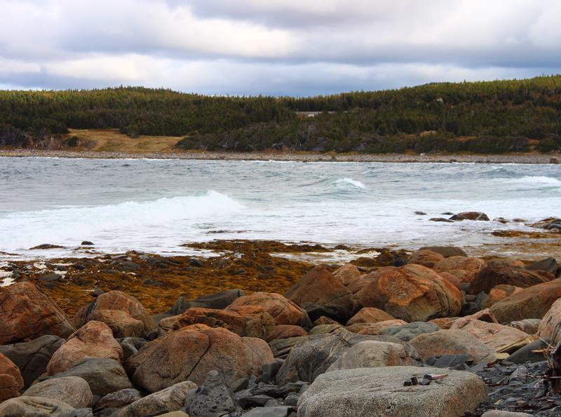
Our first stop was at Lobster Cove Head, which marks the northern side of the entrance to Boone Bay. A few kilometres inside the entrance, the bay separates into two fjords: the East Arm and the South Arm. The East Arm is by far the deepest and is practically surrounded by Gros Morne National Park, while the South Arm has a few settlements, including Woody Point, along its western shore.
In 1889, G.C. Fearn, the member of the legislative assembly for the district that included Lobster Cove, publicized the concern of the residents of his district over the lack of navigational aids in Bonne Bay. Each inhabitant of Rocky Harbour contributed a pint of oil each week to help fuel a light kept by a local fishermen in his own home. Fearn's constituents felt they merited a stronger light provided by the
government, and one resident even volunteered to keep it. "A stately old dame," Fearn wrote, "has offered to keep the lighthouse (when erected) free of salary and, said she, 'You may be sure, it will always be burning, for I have my three boys on the banks.' "
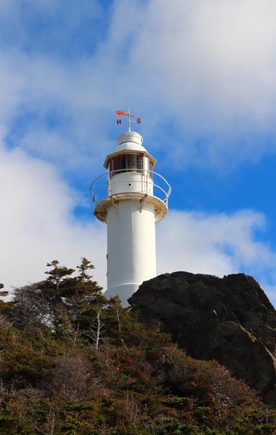
Inspector J.T. Nevill selected Lobster Cove Head in 1889 as one of four new lighthouse sites along the west coast of Newfoundland. Four years later, an iron tower was ordered from Victoria Iron Works of St. John’s, and the lantern and illuminating apparatus was ordered from Chance Brothers of Birmingham, England. In 1894, the lantern and apparatus arrived, but the light was not activated until the spring of 1898, when the necessary buildings had been constructed.
A kerosene vapour lamp was situated inside a fifth-order dioptric lens, which made twelve revolutions per minute to produce a flash every 2.5 seconds. The round, iron tower was painted white and connected via a covered way to the keeper’s dwelling, situated twenty feet to the east. The covered way and dwelling were painted white with black roofs.
Robert Lewis was appointed the first keeper of Lobster Cove Head Lighthouse at an annual salary of $504. William Young succeeded Lewis in 1902 and kept the light until 1941, when his son, George
Young, became the third and final keeper of the light. George was one of eight children raised by William and Esther Young at the lighthouse.
Lobster Cove Head became a signal station in 1898, when signal flags started to be used to send messages between ships and the shore. Each flag that was raised up the pole represented a single letter or a phrase, depending on the context. The W flag doubled as I require medical assistance, the U flag could mean You are running into danger, and the J flag carried the important message, I am on fire and carry dangerous cargo.
Automated equipment was installed in the lighthouse in 1969, and the following year, Lobster Cove Head’s final keeper, George Young, retired. Interpretive exhibits inside the dwelling describe the history of the inhabitants who lived along the nearby shore and their
dependence on the sea. One wall of the exhibit is devoted to the keepers of Lobster Cove Head Lighthouse, and one room shows how the residence was furnished when occupied by the keepers.
Lobster Cove Head Lighthouse was designated a Recognized Federal Heritage Building in 1990 because of its historical associations, and its architectural and environmental value.
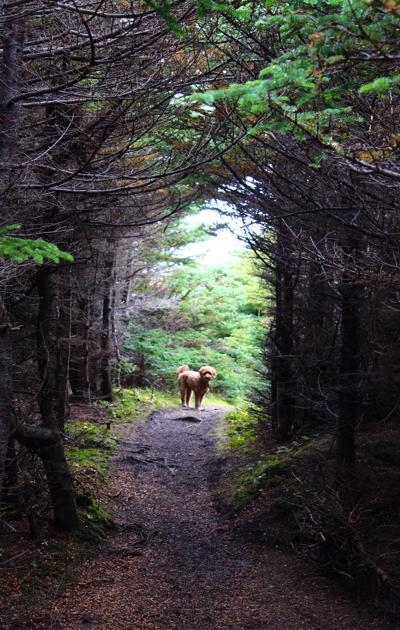
There are a series of pathways and light hiking trails that take a person down to the Lobster Cove and around the lighthouse. We were there when the tide was out and you could walk along the shores edge and view the tidal pools and the geological formations along the shore line. A beautiful day for a hike. Roxy raced ahead and wandered in and out of the woods. She was in her glory.
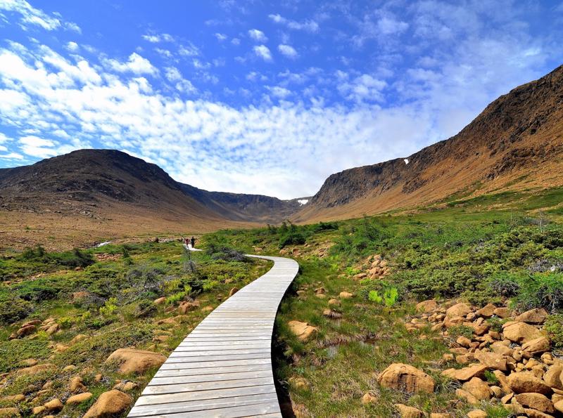
From the lighthouse we headed further up the park and ocean road to green point. Green point is one of the few places that have all-year-round camping spots in Gros Morne: 22 drive-in, 8 semi-services sites and two oTENTiks, part tent, part cabin equipped with beds, furniture and raised wooden floor. There is a ocean front hiking path that is 3 km long from one fishing village to the next. You can take an easy stroll and listen to the surf as you hike along.
We originally planned on heading up to the Western Brook Pond to go take a look at the inland fjord lake, but we decided to turn around and head to the other side of Gros Morne and drive around the Bonne Bay instead. There are 3 "ponds" in Gros Morne that are all considered fjords that are landlocked. The story is that the glaciers melted away, forming cliffs and valleys, then the land beside the ocean "rose up" and cut the fjord off from the ocean.
In the late 18th century fishermen from England began to set up permanent dwellings around Bonne Bay, relying on the seasonal resources to survive year-round in the harsh climate. Seeing a lucrative business opportunity, Joseph Bird set up a trading post in Woody Point, bartering supplies for fish and furs, which made the winter months—and life in general—easier for the inhabitants of Bonne Bay.
As more people slowly settled in Bonne Bay, the fisheries expanded, and industries such as logging sprang up. There was an increased demand for herring, which was a common bait fish in 1870s Newfoundland, as a resulting of increased cod trawling in the Newfoundland fishery. At the time there was an abundance of herring in the Bonne Bay area, resulting in the rapid growth of the local towns. Nova Scotian fishermen moving to the area had brought the art of making lobster traps and canning the meat for shipping with them. This created another boom in the local fisheries, bringing in and employing even more people. Eventually the fisheries failed due to a long period of over-exploitation. As a result the Lomond lumber mill opened up in Bonne Bay in 1920, providing winter jobs that paid in cash; a first of its kind in the area. As the years went on Bonne Bay became more and more connected with the rest of Newfoundland and the world. Now Bonne Bay is part of a UNESCO world heritage site that is visited by tourists from all over the world.
We travelled around the Bonne Bay and towards Trout River. Trout River is a small fishing community that lends to a small place where tourist always feel welcome. Trout River is home to Gros Morne’s newest backcountry hiking route - the Overfalls Trail. This easy to moderate trail winds its way through old growth forest and provides breath-taking views of the Tablelands, Trout River Pond (the land locked fjord) and the rarely seen 500ft Overfalls waterfall. Caribou, moose, black bear and arctic hare call this section of the park home. It is a beautiful piece of the countryside.
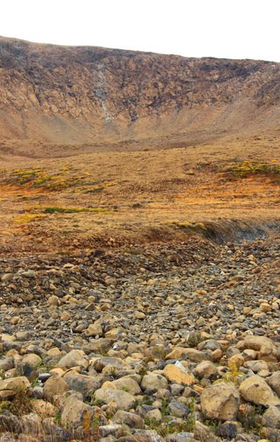
The Tablelands, found between the towns of Trout River and Woody Point in south west of Gros Morne National Park, looks more like a barren desert than traditional Newfoundland. This is due to the ultramafic rock – peridotite – which makes up the Tablelands. It is thought to originate in the Earth's mantle and was forced up from the
depths during a plate collision several hundred million years ago. Peridotite lacks some of the usual nutrients required to sustain most plant life and has a toxic quality, hence its barren and moon like appearance. Peridotite is also high in iron, which accounts for its brownish colour (rusted colour). Underneath this weathered zone, the rock is really a dark green colour. It reminds me of the "saddle" we hiked on our trip to Kilamanjaro.
On our way back to Rocky Harbour we stopped at Woody Point for lunch. About the year 1800, Bird and Company established a trading post for fur and salmon in Woody Point. The first settler was likely John Roberts about 1849. In the 1860s and 1870s, more settlers began to move to the area. Many of those were families who were engaged in the Labrador fishery, as well as drawn to the rich herring fishery.
Because of its deep-water port, Woody Point was also able to become an important shipping port. The combined economic benefits of fishing, logging and shipping enabled Woody Point to become the commercial centre for Western Newfoundland. Today the residents of Woody Point still make a living by fishing but the tourism sector has created new business and employment opportunities.
We spent much of the day exploring the area of Gros Morne and have experienced a wide range of countryside and all that the area has to offer. What a great place to enjoy not only the seaside, but also hiking in the hills. A place to come back to in the summer months when everything is in full swing.
1.
Year of Travel
2.
Sosua - Dominican Republic
3.
Our Adventures So Far...
4.
Beach Life
5.
Our Favourite Restaurants in Sosua
6.
Fun with Friends
7.
Sosua Continued
8.
Sun, Surf and Sand
9.
Samana Peninsula
10.
Sosua Highlights
11.
USA Road Trip
12.
Texas
13.
Texas
14.
Louisiana - NOLA
15.
Louisiana - NOLA
16.
Louisiana - NOLA
17.
Alabama
18.
Alabama to Tennesse
19.
Tennesse - Nashville
20.
Tennesse - Nashville
21.
Tennesse - Nashville
22.
Tennesse - Memphis
23.
Tennesse - Memphis
24.
Tennesse - Memphis
25.
Summer at Home
26.
Westcoast Adventures
27.
Europe
28.
Europe - Budapest
29.
Europe - Budapest
30.
Europe - Vienna
31.
Europe - Vienna
32.
Europe - Vienna
33.
Europe - Prague
34.
Europe - Prague
35.
Europe - Prague
36.
Europe - Berlin
37.
Europe - Berlin
38.
Europe - Berlin
39.
Europe - Salzburg
40.
Europe - Salzburg
41.
Europe - Salzburg
42.
Europe - Salzburg
43.
Europe - Salzburg
44.
Europe - Innsbruck
45.
Europe - Innsbruck
46.
Europe - Bad Ragaz
47.
Europe - Bad Ragaz
48.
Europe - Lindau
49.
Europe - Lindau
50.
Europe - Fussen
51.
Europe - Fussen
52.
Europe - Freising and Munich
53.
San Francisco
54.
San Francisco
55.
San Francisco
56.
San Francisco
57.
San Francisco
58.
San Francisco
59.
Canada Road Trip
60.
On the Road to Ontario
61.
Ontario - Thunderbay
62.
Ontario - Thunderbay
63.
Ontario - Thunderbay
64.
Ontario - Toronto
65.
Ontario - Ottawa
66.
Ontario - Ottawa
67.
Quebec - Montreal
68.
Quebec - Montreal
69.
Quebec - Montreal
70.
Quebec - Quebec City
71.
Quebec - Quebec City
72.
Quebec - Sainte Flavie
73.
New Brunswick - Bathurst
74.
New Brunswick - Shediac
75.
New Brunswick - Shediac
76.
Prince Edward Island - Charlottetown
77.
Prince Edward Island - Road trip
78.
Prince Edward Island - Charlottetown
79.
Prince Edward Island - More exploration
80.
Nova Scotia - Halifax
81.
Nova Scotia - Halifax
82.
Nova Scotia - Halifax
83.
Nova Scotia - Sydney
84.
Newfoundland - Channel-Port
85.
Newfoundland - Rocky Harbour
86.
Newfoundland - Rocky Harbour
87.
Newfoundland - St. John's
88.
Newfoundland - St. John's
89.
Newfoundland - St. John's
90.
Newfoundland - St. John's
91.
Newfoundland - St. John's
92.
Newfoundland - Travelling
93.
Nova Scotia - Sydney
94.
New Brunswick - Saint John
95.
Maine - Portland
96.
Massachessets - Cape Cod via Boston
97.
Massachusetts - Cape Cod
98.
Massachusetts - Cape Cod
99.
Pennsylvania - Clearfield
100.
Illinois - Chicago
101.
Illinois - Chicago
102.
Illinois - Chicago
103.
Heading Home
104.
Our Year at a Glance
Share your travel adventures like this!
Create your own travel blog in one step
Share with friends and family to follow your journey
Easy set up, no technical knowledge needed and unlimited storage!